Skiathos, Sporades – A Sailor’s Guide

Skiathos Island, Greece

Skiathos, Sporades – A Sailor’s Gem of the Aegean

Skiathos is the lively heart of the Northern Sporades, a small yet captivating island where lush pine forests kiss golden beaches and the sea sparkles like liquid sapphire.
To sailors, Skiathos Island is more than a postcard—it’s a dependable refuge, a provisioning stop, and a scenic launchpad for exploring the rest of the archipelago. With secure holding grounds, modern facilities, and short passages to neighboring islands, it’s no surprise that Skiathos has become one of the most beloved sailing hubs in the northwest Aegean.

Skiathos – Quick Facts

Island: Skiathos (Northern Sporades)
Region: Thessaly, Greece
Coordinates: 39.1500, 23.4833
Main Port: Skiathos Town Marina
Depths: 3–8 m typical
Seabed: Sand & weed, very good holding
Protection: Best from N–NW; open to S–SE
Season: May–October
Water & Fuel: At marina quay
Mobile Data: Strong 4G/5G

From Volos: ~35 NM
To Skopelos: ~12 NM
To Alonissos: ~25 NM
Notes: Mind the reefs around Tsougrias Island on approach. Arrive early July–August.

Location & Coordinates

Skiathos lies closest to the Greek mainland among the Sporades islands, about 35 nautical miles northeast of Volos. The island’s harbor faces south, sheltered behind the Bourtzi peninsula, and serves as a strategic waypoint between the mainland and the outer Sporades.

Approaching from the west or south is straightforward, though sailors should avoid the reefs near Tsougrias Island just off the main harbor. The coastline is well-charted, with clear visual cues such as the Skiathos lighthouse and forested hills visible from afar.

Characteristics

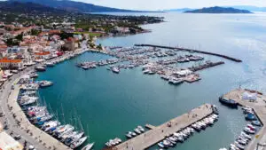
  • Skiathos Town Bay is ideal for convenience—close to shops, nightlife, and services, though it can get busy in summer.

  • Koukounaries Bay on the southwest coast is a scenic favorite, with a long sandy beach and lush backdrop, though open to southerly swell.

  • Tsougrias Island, just opposite the port, is a quiet haven with turquoise waters and solid sand patches for day anchoring.

Water clarity is exceptional, and holding remains consistent even in stronger winds. Most anchorages are safe for overnight stays when the weather is stable.

Amenities

Skiathos Marina and town provide everything a sailor might need before heading deeper into the Sporades:

  • Fuel & Water: Supplied directly at the marina quay.

  • Provisions: Several supermarkets and a daily fresh produce market.

  • Repairs: Basic mechanical, electrical, and rigging services available.

  • Dining: Numerous tavernas and cafés line the harbor promenade.

  • Connectivity: Strong 4G/5G and free Wi-Fi in several bars.

  • Mooring: Lazy lines and side-to mooring for yachts.

  • Showers & Laundry: Available in nearby facilities.

  • Medical Services: Pharmacy and clinic within walking distance.

Routes & Distances

FromToDistance (NM)Notes
VolosSkiathos35Straightforward passage from mainland
SkiathosSkopelos12Calm channel crossing
SkopelosAlonissos13Scenic inside route
SkiathosPelion Coast30Easy return leg westward
SkiathosKyra Panagia40For longer Aegean adventure

Suggested Route: Volos → Skiathos → Skopelos → Alonissos → Kyra Panagia → return.
This loop provides a complete Sporades experience with minimal long passages.

Feedback from Sailors

Sailors consistently praise Skiathos for its excellent infrastructure, friendly marina staff, and good holding conditions. The proximity to the airport makes crew changes easy, and the town’s nightlife adds a cheerful break to longer voyages.
However, high season (July–August) can bring crowded moorings, so it’s best to arrive early in the day or reserve ahead.

FAQs about Anchoring in Skiathos

Q1: Is anchoring allowed here?
Yes, anchoring is allowed in several bays including Koukounaries, Tsougrias, and the town anchorage.

Q2: What is the seabed and how is the holding?
The seabed consists mainly of sand and weed, offering excellent holding in 3–8 meters.

Q3: What depths are typical for anchoring?
Most safe anchorages range between 3–8 m, with clear patches of sand visible even from the surface.

Q4: How protected is it from the Meltemi?
Northern bays are well-protected; southern and open coastlines can experience swell in southerly winds.

Q5: Is it rolly at night or subject to swell?
In calm weather, nights are peaceful. The southern coast may get gentle rolling during south or southeast winds.

Q6: Are there mooring buoys or a dock/quay?
Yes, Skiathos Town Marina provides lazy lines. Outlying bays require free anchoring.

Q7: Is there an easy dinghy landing?
Yes, the marina offers a safe dinghy dock near the fuel station; sandy beaches also make for easy landings.

Q8: Can I get fresh water, fuel, or provisions nearby?
All are available at the marina quay, with multiple supermarkets a few minutes’ walk away.

Q9: What are the nearest ports or anchorages for the next leg?
Skopelos lies 12 NM east, while Volos is 35 NM west — both reachable in a comfortable day sail.

Q10: Is Skiathos suitable for beginners and families?
Absolutely. Calm waters, short distances, and reliable holding make Skiathos perfect for new skippers and family crews.

Conclusion

Skiathos is more than a stop—it’s an experience. From its bustling harbor and pine-shaded beaches to its easy approach and solid anchorage, it perfectly blends practicality with Aegean charm. Whether you’re refueling for your Sporades circuit or savoring a night beneath the island lights, Skiathos will remind you why sailing Greece is pure magic.

For nearby destinations, explore Skopelos, Alonissos, and Kyra Panagia in the Evia and the Northern Sporades sailing guide, or, Eastern Sporades sailing routs.

Koukounaries Bay – Quick Facts

Island: Skiathos (Northern Sporades)
Region: Thessaly, Greece
Coordinates: 39.1482, 23.4006
Nearest Port: Skiathos Town Marina (~7–8 NM by sea)
Depths: 4–9 m typical
Seabed: Sand with weed; good holding
Protection: Best in N–NW; exposed to S/SW swell
Season: May–Oct (crowded Jul–Aug)
Water & Fuel: At Skiathos Marina
Mobile Data: Strong 4G/5G

To Skiathos Town: ~7–8 NM
To Tsougrias: ~6–7 NM
To Skopelos: ~14–16 NM
Notes: Wide sandy bay; anchor on sand patches. Expect wakes/daytime traffic; calmer evenings.

Tsougrias Island – Quick Facts

Island: Tsougrias (off Skiathos)
Archipelago: Northern Sporades
Coordinates: 39.1200, 23.5000
Nearest Port: Skiathos Town (~2–4 NM run)
Depths: 3–8 m on sand patches
Seabed: Sand; excellent holding
Protection: Limited; exposed in southerlies
Best Use: Day stop / fair-weather overnight

To Skiathos Town: ~2–4 NM
To Koukounaries: ~6–7 NM
To Skopelos: ~12–14 NM
Notes: Crystal water; popular with day boats. Avoid in strong S/SE; check for swim buoys in season.

Skopelos (Town) – Quick Facts

Island: Skopelos (Northern Sporades)
Region: Thessaly, Greece
Coordinates: 39.1404, 23.7068
Approach: From W via Skiathos channel
Mooring: Town quay/lazy lines; anchor with care
Depths: 3–6 m in the bay (check berths)
Protection: Good overall; avoid strong N gale in outer parts
Season: May–Oct
Water & Fuel: Water on quay; fuel by truck (seasonal)
Mobile Data: Strong 4G/5G

From Skiathos: ~12 NM E
To Alonissos (Patitiri): ~13 NM
To Panormos Bay: ~8–10 NM W coast
Notes: In northerly blows the outer harbor can be choppy; use better-sheltered bays (Agnondas/Panormos).

Alonissos – Patitiri – Quick Facts

Island: Alonissos (Northern Sporades)
Region: Thessaly, Greece
Coordinates: 39.1460, 23.8643
Harbor: Patitiri (main port)
Mooring: Town quay; limited berths in peak
Depths: 3–6 m (check berth soundings)
Protection: Good in prevailing; surge possible with strong E/SE
Season: May–Oct
Water & Fuel: Water on quay; fuel by truck
Mobile Data: Strong 4G/5G

From Skopelos Town: ~13 NM E
From Skiathos: ~25 NM E
To Marine Park (Kyra Panagia): ~20–25 NM NE
Notes: Good base for provisioning before Marine Park. Watch for ferry wash near quay.

Panormos Bay – Quick Facts

Island: Skopelos (Northern Sporades)
Coordinates: 39.0870, 23.6560
Depths: 5 – 10 m
Seabed: Sand & weed; excellent holding
Protection: Excellent from Meltemi; gusts off hills possible
Water & Fuel: At Skopelos Town (10 NM E)
Best Use: Overnight anchorage / swim stop
Season: May – Oct

From Skopelos Town: ~10 NM W
To Skiathos: ~20 NM W
To Agnondas: ~4 NM SE
Notes: Sheltered natural harbour; restaurants ashore; excellent snorkelling.

Agnondas – Quick Facts

Island: Skopelos (Northern Sporades)
Coordinates: 39.0790, 23.6990
Depths: 4 – 7 m
Seabed: Sand and weed; good holding
Protection: Excellent from Meltemi
Facilities: Small pier, tavernas ashore
Best Use: Shelter anchorage
Season: May – Oct

To Skopelos Town: ~4 NM E
To Panormos: ~4 NM W
To Skiathos: ~18 NM W
Notes: Use stern-to the pier or anchor off; good backup to Chora harbour.

Stafylos Bay – Quick Facts

Island: Skopelos (Northern Sporades)
Coordinates: 39.0945, 23.7570
Depths: 5 – 8 m
Seabed: Sand with weed; good holding
Protection: Limited; open to E/SE
Best Use: Day stop & swimming
Distance from Chora: ~2 NM S
Season: May – Oct

To Skopelos Town: ~2 NM N
To Agnondas: ~3 NM W
To Panormos: ~8 NM W
Notes: Clear water; great for snorkelling; avoid overnight in strong E/SE winds.

Kyra Panagia (Planitis Bay) – Quick Facts

Island: Kyra Panagia (Northern Sporades Marine Park)
Coordinates: 39.3630, 24.0830
Depths: 6–12 m typical inside inlet
Seabed: Sand with weed; good holding
Protection: Excellent from Meltemi within Planitis
Facilities: None (remote, protected area)
Permits/Rules: Marine Park regulations apply
Season: May–Oct (best in settled weather)

From Patitiri (Alonissos): ~20–25 NM
From Skopelos Town: ~30–35 NM
From Skiathos: ~40–45 NM
Notes: Narrow N entrance (Planitis) opens into a landlocked basin—excellent storm hole. No services; pack water, fuel, and provisions in Alonissos first.

Loutraki (Glossa) – Quick Facts

Island: Skopelos (Northern Sporades)
Coordinates: 39.1667, 23.6150
Depths: 3 – 7 m
Seabed: Sand & mud – good holding
Protection: Excellent from Meltemi
Mooring: Town quay / lazy lines (seasonal)
Fuel & Water: By truck on request
Shops & Cafés: Ashore near ferry dock

To Skiathos: ~8 NM W
To Skopelos Town: ~12 NM E
To Panormos: ~9 NM S
Notes: Calm anchorage; ferry wash occasional. Ideal crew change point with bus to Chora and airport ferries to Skiathos.

Neo Klima (Elios) – Quick Facts

Island: Skopelos (Northern Sporades)
Coordinates: 39.1225, 23.6310
Depths: 3 – 6 m at quay
Seabed: Mud and sand; good holding
Mooring: Marina berths / lazy lines
Protection: Excellent from Meltemi
Fuel & Water: By truck on request
Shops & Dining: Restaurants, mini-markets ashore

To Panormos: ~3 NM S
To Loutraki: ~6 NM N
To Skopelos Town: ~10 NM E
Notes: Reliable shelter with modern pontoon berths; popular charter overnight stop.

Peristera Island – Quick Facts

Island: Peristera (Northern Sporades Marine Park)
Coordinates: 39.1600, 23.9900
Depths: 5 – 12 m
Seabed: Sand / weed; good holding
Protection: Good in N winds; open to E/SE
Facilities: None (remote island)
Best Use: Swim stop / overnight in settled weather
Permits: Marine Park rules apply

From Patitiri (Alonissos): ~6 NM E
To Kyra Panagia: ~20 NM NE
To Skopelos: ~22 NM W
Notes: No infrastructure; excellent snorkelling and calm night anchorage in light winds.

Share:

Greece Travel Articles & Guides

Explore Greece by Sea with GrecoSailor: Personalized Itineraries for Every Traveler

– Sail Your Dream Adventure in Greece: Tailored Itineraries, Unforgettable Memories.
– Explore the Magic of the Greek Seas, Your Way.
– Custom Sailing Itineraries Designed Just for You.

Contact Us Now to Create Your Dream Sailing Itinerary [email protected]